
GDV for earthquake forecasting
The Energy of Space
Method and device for earthquake forecasting
Abstract
FIELD: seismology.
SUBSTANCE: invention relates to seismology and can be used to predict earthquakes.
Essence: in the controlled area, a device is installed to ensure the recording of gas-discharge air imaging on the surface of the medium.
Device comprises an optically transparent electrode, a gas discharge glow detection means, means for creating an electromagnetic field between the electrode and gas-discharge glow detection means, and a gas-discharge glow parameter processing unit.
Record the parameters of gas-discharge glow. Forthcoming earthquake is judged by reducing the area of gas-discharge luminescence by less than 20 %, while at the same time increasing the intensity of the gas-discharge glow by at least 1.5 %.EFFECT: simplification of forecasting of medium and strong earthquakes.12 cl, 2 dwg
1. A method of predicting an earthquake zone, characterized in that the controlled area is set the device, ensuring registration discharge air visualization on the medium surface, comprising an optically transparent electrode, gas discharge detection means, means for creating an electromagnetic field between the electrode and the gas-discharge means for registering the luminescence connected to a conductive electrode portion, and a block parameter processing gas discharge, the gas discharge spark recorded parameters Nia, with the impending earthquake is judged by the reduction gas discharge area of less than 20% while increasing the gas-discharge luminescence intensity not less than 1.5%.
2. A method according to claim 1, characterized in that the gas discharge glow is generated by supplying high-voltage pulses at a repetition frequency electrode 1000 ± 100 Hz.
3. A method according to claim 1, characterized in that the gas discharge parameters were recorded continuously.
4. A method according to claim 1, characterized in that the gas discharge parameters were recorded periodically.
5. A method according to claim 1, characterized in that the electrode is mounted on outdoors.
6. A method according to claim 1, characterized in that the time measuring unit is less than 10 microseconds.
7. A method according to claim 1, characterized in that the voltage supplied to the electrode with single pulses once per 60 seconds.
8. Apparatus prediction earthquake zones, characterized in that it comprises an optically transparent electrode, gas discharge detection means, means for creating an electromagnetic field between the electrode and the gas-discharge means for registering the luminescence that is connected to the conductive portion of the electrode, processing parameters and block gas discharge.
9. The apparatus according to claim 8, characterized in that the optically transparent electrode is a dielectric plate coated with a layer of conductive material, said conductive layer facing toward the gas discharge recording means.
10. The apparatus according to claim 8, characterized in that the detection means is a gas discharge CCD.
11. The apparatus according to claim 8, characterized in that the means for creating an electromagnetic field of high intensity is a pulse generator with a frequency of 1000 ± 100 Hz.
12. The apparatus according to claim 8, characterized in that the processing means of gas discharge parameter is a personal computer with appropriate software.
Description
GDV for earthquake forecasting translated from Russian
The invention relates to the field of geophysics, and can be used to predict earthquakes.
Earthquakes are tremors and fluctuations in the Earth’s surface. The most dangerous of them arise due to offsets and tectonic fractures in the earth’s crust and upper mantle portion. Fluctuations from them in the form of elastic seismic waves are transmitted over long distances, and in the vicinity of the centers of earthquakes, they can become a cause of damage to buildings and loss of life. Earthquakes and related phenomena is studying a special science – seismology, which conducts research in the following areas:
1. The study of the nature of earthquakes, in other words, looking for an answer to the question: why, how and where they occur.
2. Application of knowledge about earthquakes to protect them by forecasting possible in one place or another seismic shock for the construction resistant to the effects of their designs and constructions.
3. Study of the Earth’s interior structure and exploration of mineral deposits using seismic waves from earthquakes and artificial seismic sources.
Nowadays range of devices that register vibrations of the earth, is quite high. There is an opportunity to learn about what happened the earthquake, literally “without leaving home” – opening a page on the Internet. For the year recorded more than a million different earthquakes, the strength of the Earth wobble usually poses no threat to the life of the population.
Earthquakes are known, generally, for the destruction which they are applied. At the same time dangerous not only the underground vibrations, as well as many other phenomena associated with them, such as tsunamis, lava emissions of volcanic gas and ash to the surface. Unfortunately, their popularity is higher, the longer they take human victims. This occurs most often in areas of high seismic activity, and these areas are known to mankind. Using the equipment, which may signal an impending earthquake in advance, can help to avoid human casualties, as well as man-made accidents.
Is known (RU, patent 2453871, publ. 20.06.2012) a method for predicting earthquakes by predicting it by forerunner. According to the known method produces a local compensation of the geomagnetic field well before the earthquake by creating compensating magnetic field of opposite tension geomagnetic field and monitoring the spontaneous violation of the compensated magnetic field, wherein a precursor earthquake occurrence determined by the occurrence of the violation and the appearance of an additional component of the magnetic field strength that violates the local payment geomagnetic fields, and produce a bearing on several Dalen apart places expected epicenter of the earthquake observation in the direction of the vector component of the additional magnetic field.
To implement this method, an apparatus, comprising a rack mounted on the base with a magnetic compass arrow on the needle, the azimuth compass scale with possibility of adjusting its rotation around the magnetic needle of a compass. It is further provided a fortified on racks turntable circular wire frame – the solenoid, the center of symmetry of which coincides with the center of the magnetic compass needle, and its diameter is disproportionately greater than the length of the magnetic needle of a compass, with the possibility of adjusting the rotation of wire frames around a diametral horizontal axis and, together with the turntable , about a vertical axis, the circular wire frame included in the electric circuit comprising a source of steady dc voltage inverter detecting current, switch, normally closed button and control the current.
The disadvantage of this technical solution is the need for, and a large amount of pre-preparatory work, the dependence of the results from external magnetic fields, and the complexity of the method used in the equipment.
Also known (RU, patent 2489736. publ. 08.10.2013) a method for detecting the possibility of occurrence of catastrophic events. According to the known method the measurement is a parameter geophysical field in a controlled area and a judgment from the data of the possibility of catastrophic events, wherein the measurement is carried out continuously, reveal fluctuations measured value and exhibit sinusoidal oscillations increasing frequency having an amplitude significantly different from the background for the controlled area, and a period of from 100 to 1,000,000 with, the simultaneous recording is performed in the pressurized atmosphere and evap s, the determination of each selected point of a sum of increments of the amplitude function of pressure and temperature versus time, identifying the values of said parameter area not equal to zero, the judgment about the time of occurrence of an earthquake on the time of appearance of these bands, the place of the earthquake is judged by the spatial position of such zones, Thus in one of claims seismic regions further diagnose atmosphere changes wave mode from regular measurements of the total content of ozone in the atmosphere in the sliding time window m Tod Fourier analysis, comparing the variation of seismic frequency ranges in the data RAM ozonometers, predetermined according to archival data, with reference seismogenic trends activation treble amid recession low frequencies emit seismic dangerous periods and specify the time of occurrence of the earthquake, but by definition manifestations of these effects and their duration is set approximate force of the earthquake, according to the peculiarities of the spatial structure of the spectral effects set position epicyte tral zone. In this further operate regular deep seismic sounding in the bottom ground in a controlled area, the measurement of the sea ground vibrations operate on discrete areas of the sea waters at different times so that the measurement obtained at each measurement point have different values of time intervals relative to the nearest to the moment of measurement of the last points in the upper culmination of the moon on a fixed geographic meridian, for the analysis of microseismic waves operate for I transverse microseismic waves, while for all the emitting portion microseismic discrete points are selected from all the harmonics of the two broadband seismic receivers reflected simultaneously with substantially equal amplitudes and lying in the redistribution of the angle of arrival of the reflected waves.
The above method is technically complicated and time-consuming, is mainly designed for the prediction of earthquakes on the seabed.
GDV for earthquake forecasting
Is known (RU, patent 2282220, publ. 20.08.2006) a method for determining the time, place and magnitude of earthquakes, comprising identifying seismogenerating zones potentially base structures for various purposes, placement in these zones a set of points of measurement of geophysical quantities measurements and in their result of the detection of anomalies due to rock deformation zones above holding space-time mapping analysis anomalies allocation precursors (foreshocks) earthquakes Zateev definition of the epicenter, time and magnitude of strong earthquakes.
The disadvantage of this method is that the basis of the method is the assumption of the existence of a common co-directional tangential stress axes to outbreak foreshocks – weak earthquakes precede the main event, whereas the directions of these axes may form a considerable angle during large area preparation of strong earthquakes. In addition, the method is not sufficient criteria and selection procedure foreshocks clearly described from the whole set of seismic events in this region. All this reduces the reliability and accuracy of the method and the accuracy of determining the position of the predicted epicenter of a strong earthquake. In this case, possible ambiguity in determining the location, time and magnitude of an earthquake that could have an impact on the base of designed or existing facilities.
The technical problem solved by using the developed method and apparatus is to provide the prediction zone (chamber) of medium and strong earthquakes.
The technical result achieved when implementing the developed method and apparatus is their simplification.
To achieve said technical result suggested to use the developed method earthquake prediction zone. According to the developed method airside mounted device providing registration discharge visualization of air on the surface of the medium and containing the optically transparent electrode, the detection means gas discharge, means for creating an electromagnetic field between the electrode and means for registering gas discharge connected to the conductive portion of the electrode, and a block parameter processing gas discharge, and record the parameters of gas discharge glow generated electromagneti bubbled pulses, wherein the impending earthquake is judged by the reduction gas discharge area by at least 20% while increasing the gas-discharge luminescence intensity not less than 1.5%.
Experimentally observed that over the hearth quake for a few hours before it starts infrasonic vibrations are generated in the range up to 6 Hz, which leads to a change in electrical characteristics of the air above the region of the earthquake. The presence of these infrasonic vibrations that cause discomfort to the condition of animals and birds, has long been used to predict future earthquakes.
It has been experimentally established that changes the character before the eruption of gas discharge air luminescence over future earthquake zone. Presumably electromagnetic radiation caused by the processes occurring within the earth to earth vibrations inscribed sensor is amplified by gas discharge, which makes it possible to visualize this electromagnetic radiation.
This was the basis for the development of these technical solutions.
Preferably, the gas discharge glow is generated by supplying to the electromagnetic field pulses of high tension electrode (duration roughly 10 ms with a repetition rate of 1000 ± 100 Hz.).
The electrode is preferably mounted on outdoors.
Advantageously, the measurement time unit is less than 10 microseconds.
Typically, high voltage is applied to the electrode with single pulses once per 60 seconds (exposure may vary from 0.5 seconds to 30 seconds).
To achieve said technical result, to use the requested zone designed earthquake prediction device.It comprises an optically transparent electrode, gas discharge detection means, means for creating an electromagnetic field between the electrode and the registering means connected to the conductive portion of the electrode, and a processing unit for the gas discharge parameters.
Preferably, the optically transparent electrode is a dielectric plate (glass) coated with a layer of conductive material (tin or titanium oxide), wherein the conductive layer is facing towards the means of recording parameters gas discharge.
Registration means is a gas discharge CCD or formed at its base camcorder.
Means for creating a high intensity electromagnetic field is a high voltage pulse generator with a frequency of 1000 ± 100 Hz.
Gas discharge means for processing parameters is the program a personal computer with appropriate software.
Experimental test developed technical solutions conducted between mid-December 2015 to April 2016 (inclusive).
The venue of the Republic of Moldova was chosen as an experiment, Taraclia district. This area has a sufficient seismic activity.
GDV for earthquake forecasting
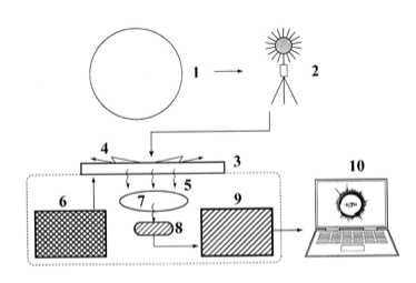
It was used to design a device whose block diagram is shown in FIG. 1, the following symbols are used: object of study 1 (air), an optically transparent electrode 2, the gas discharge 3, emission region 4, generator 5, the optical system 6, the video converter 7, 8, 9, parameter processing means.
The equipment was in non-residential, isolated room, without any additional heating.
Diurnal measurements were performed, the shooting mode – 30 seconds.
We considered only with the vibrations of an earthquake above 2.8 points and a source of up to 200 km away from the installation area. Geographically, this mainly European earthquake epicenter – Eastern the Carpathians, Physician zone, Romania (Zona seismica Vrancea, judetul Buzau, Zona seismica Vrancea, judetul Vrancea).
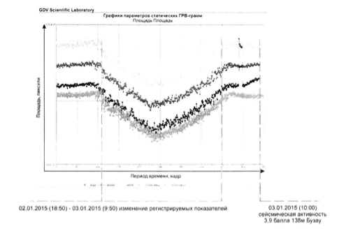
FIG. 2 is a typical view taken options in a graphical form.
More than 6 million charts was obtained.
The following conclusions were reached:
1. In most cases, for about 8-14 hours before the earthquake signal changes have been recorded;The most informative and sensitive parameters are area and average intensity.
2. There were three types of change, it is believed that it may be associated with different types of earthquakes, sources of which are different tectonic plates.
For example:
03/14/2015 00-31, the platform 3, 9 points, 118 km, Buzau
The decrease in the glow area before the earthquake 22.36%
The increase of the luminescence intensity before the earthquake 2.25%
03/16/2015 17-49, 4, 6 points, 115 km, Buzau
The decrease in the glow area before the earthquake 29.95%
The increase of the luminescence intensity before the earthquake 2.83%
3. There were also documented other parameter changes, probably related to the regular weather events.
This invention will allow to predict the imminent fluctuation earth’s surface within a radius of 100-150 km from the epicenter, for 4-5 hours before the earthquake. Also, the data will indicate the strength of future earthquakes.
Presumably electromagnetic radiation caused by the processes occurring within the earth to earth vibrations inscribed sensor is amplified by gas discharge, which makes it possible to visualize this electromagnetic radiation.
GDV for earthquake forecasting
Patent RU2655027C1
GDV Sputnik and The Energy of Space
GDV for earthquake forecasting
